Semester
Subject
Year
Bachelors In Information Technology
Institute of Science and Technology, TU
Geographical Information System (BIT355)
Year Asked: Model, syllabus wise question
Data Acquisition Techniques in GIS
1.
What is remote sensing? Explain the Components of remote sensing. [10]
Map Projection and Coordinate System
1.
What is Coordinate system? Explain the difference between Geographic coordinate system (GCS) and Projected coordinate system (PCS). [5]
2.
What is projection? How do you import GPS file to make shape file. Explain the steps. [5]
Mapping the Real World with Vector and Raster Data
1.
What is Spatial Data Model? Explain vector data model and raster data model with application area. [10]
Open GIS and Applications
1.
Explain the Open Vs Commercial GIS Program with example. [5]
Raster Data Analysis
1.
What do you understand by Local Raster operations? Explain with example [5]
The Basics of Geographic Information System
1.
What are the components of GIS? Explain all in brief. [10]
Vector Data Analysis
1.
What is Topology? Explain the importance of topology in GIS. [5]
2.
Define a buffer zone. Describe and explain three variations in buffering. [5]
3.
Refer to the following figure, draw a quadtree, and code the spatial index of the shaded (spatial) feature. 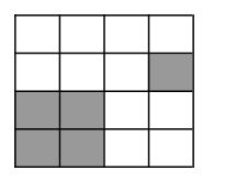 [5]
[5]
4.
What is overlay? Explain overlay operations: point-in-polygon with example. [5]
5.
Write short notes on: TIN Write short notes on: DEM [2.5+2.5]